Magnetic Island - Définition
La liste des auteurs de cet article est disponible ici.
Introduction
| Magnetic Island | ||
| ||
| Géographie | ||
|---|---|---|
| Pays |

| |
| Localisation | Mer de Corail | |
| Coordonnées | ||
| Superficie | 52 km2 | |
| Point culminant | Mount Cook (497 m) | |
| Administration | ||
| Démographie | ||
| Population | 2 107 hab. | |
| Densité | 40,52 hab./km2 | |
| Autres informations | ||
| Fuseau horaire | UTC+10 | |
| Site officiel | (en)http://www.magnetic-island.com.au/ | |
| ||
| Îles d'Australie | ||
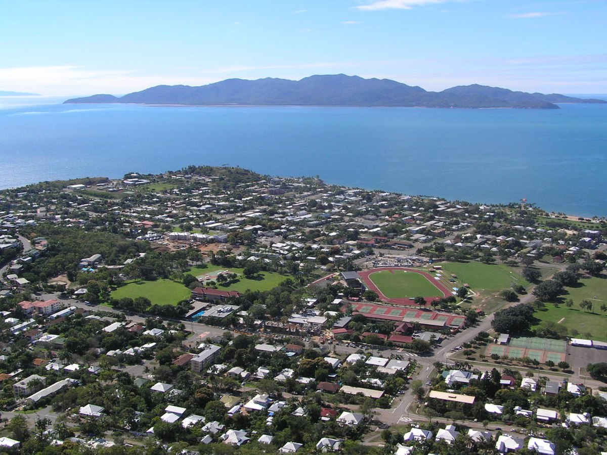
Magnetic Island, située à 8 km au large de la ville de Townsville (Queensland, Australie), dans la Baie de Cleveland est une île montagneuse de 52 km² qui est véritablement devenue une banlieue de Townsville avec 2 107 résidents permanents. L'île est accessible de Townsville à Nelly Bay par ferry (deux compagnies se partagent le marché : Sunferries et Fantasea Cruises). L'île abrite un large parc national de 27 km², qui est un sanctuaire pour les oiseaux et d'excellents parcours de randonnée relient les baies populeuses aux nombreuses destinations touristiques, tels les forts de la Seconde Guerre mondiale.
L'île est depuis longtemps devenue une destination de vacances, avec de nombreux hôtels et plusieurs complexes touristiques offrant tous niveaux de services. Les commodités et les infrastructures sur l'île sont gérées par la Cité de Townsville (Townsville City Council). L'île fait partie du District électoral de Townsville (représenté par Mike Reynolds) dans l'Assemblée législative du Queensland.
Étymologie
Le nom de l'île provient de l'apparent effet "magnétique" qu'elle eut sur le compas des navires du Capitaine Cook lorsque celui-ci passa près de l'île au cours de sa navigation le long de la côte est de l'Australie en 1770. Depuis lors, des gens ont exploré l'île à l'aide de divers instruments afin de découvrir ce qui pouvait être la cause de l'effet reporté par Cook, mais rien n'a été découvert.
Histoire
Les jeunes années
Le nom de Picnic Bay provient de sa popularité en tant que lieu de pique-nique pour touristes européens venus du continent dans les années 1800, avant que Magnetic Island ne soit investie par des Européens. Dans le milieu des années 1800, l'île devint un endroit fréquenté pour la collecte d'Araucaria cunninghamii, de pierre et de corail, nécessaires à le développement du continent. En 1875, l'île fut isolée en tant que station de quarantaine bien qu'il fallut dix années supplémentaires pour que des commodités soient proprement installées à West Point.
Vers 1890, un complexe touristique vit le jour à Picnic Bay. En 1898, Robert Hayles Sn. fut si impressionné par le potentiel de Magnetic Island qu'il vendit ses autres intérêts pour construire un complexe sur l'île. Hayles fut responsable d'une bonne part du développement de Magnetic Island à travers le tourisme. En 1901, il lança un service régulier de ferry service vers l'île avec son bateau, le "Bee" (l'"Abeille"). Douze mois plus tard, ce bateau échoua sur des rochers à Nobby Head, Picnic Bay et le Phoenix fut construit par les fils de Hayles pour le remplacer. La compagnie Hayles maintint des services d'exploitation avec un grand nombre de bateaux différents jusque les années 1970.
Seconde Guerre mondiale
En 1942, Townsville devint une importante base en Australie pour les troupes provenant d'Australie et des Etats-Unis et Cleveland Bay, entre Magnetic Island et Townsville, devint un important point de assembly pour les approvisionnements et les navires militaires également. To ensure the assembling fleets were safe from enemy attack, a large military facility, The Forts, as the remaining remnants are now known by, was built on Magnetic Island. It included two Sperry 3,000,000 candle power searchlights located at Horseshoe and Florence Bays, a radar screen in the hills above Arthur Bay operated by the 13th Australian Radar Unit and two gun emplacements overlooking the southern entrance to Cleveland Bay (the northern entrance is too shallow for large ships to navigate) as well as the facilities to support these and the detachments assigned to look after these facilities.
The two guns located at Magnetic Island were promptly removed following the war but are one of the most controversial issues surrounding the history of The Forts. It is often contested whether either of the guns ever fired a shot. It is well known that the guns never fired on an enemy vessel; however, it is believed, although not confirmed, that the gun facing the harbour entrance did fire on a boat which was not flying any colours. Information signs around the guns claim that the gun fired a shot "in mild astonishment" when a US navy boat "arrived unannounced".
It is also sometimes considered that four guns were deployed for emplacement at Magnetic Island during the war. However, in early 1999 a letter to the Townsville Bulletin from an Eric Hall claimed that his father, being the tug master of Townsville Port at the time, towed only two guns aboard a barge to Rollingstone Bay at the northeastern end of Magnetic Island.
The Forts is now a popular attraction for tourists to Magnetic Island. Located high in the hinterland of Horseshoe, Arthur, Florence and Radical Bays, the walk to the remains of the facility is a popular place to spot koalas and includes a number of views over the surrounding bays and ocean. The gun emplacements, command post and observation post are all open to public access. The command post, still operational as a radio tower, provides an exceptional 360-degree view of the surrounding bays out to the ocean.
Après-guerre
The island slowly expanded following the end of the Second World War. In late December 1971 Cyclone Althea hit the North Queensland coast directly crossing Magnetic Island. The island, along with much of the mainland, was devastated with 90% of the island's houses damaged or destroyed, some simply lifted off their foundations and tossed into trees. The island, along with the mainland, soon recovered.


