How do sandstorms form? 🌪️
Published by Adrien,
Source: The Conversation under Creative Commons license.
Other Languages: FR, DE, ES, PT
Source: The Conversation under Creative Commons license.
Other Languages: FR, DE, ES, PT
Follow us on Google News (click on ☆)
It is common during spring and summer, in Europe including mainland France, to find your car covered with a fine layer of white or yellowish dust, whose origin is actually a dust storm from the Sahara.

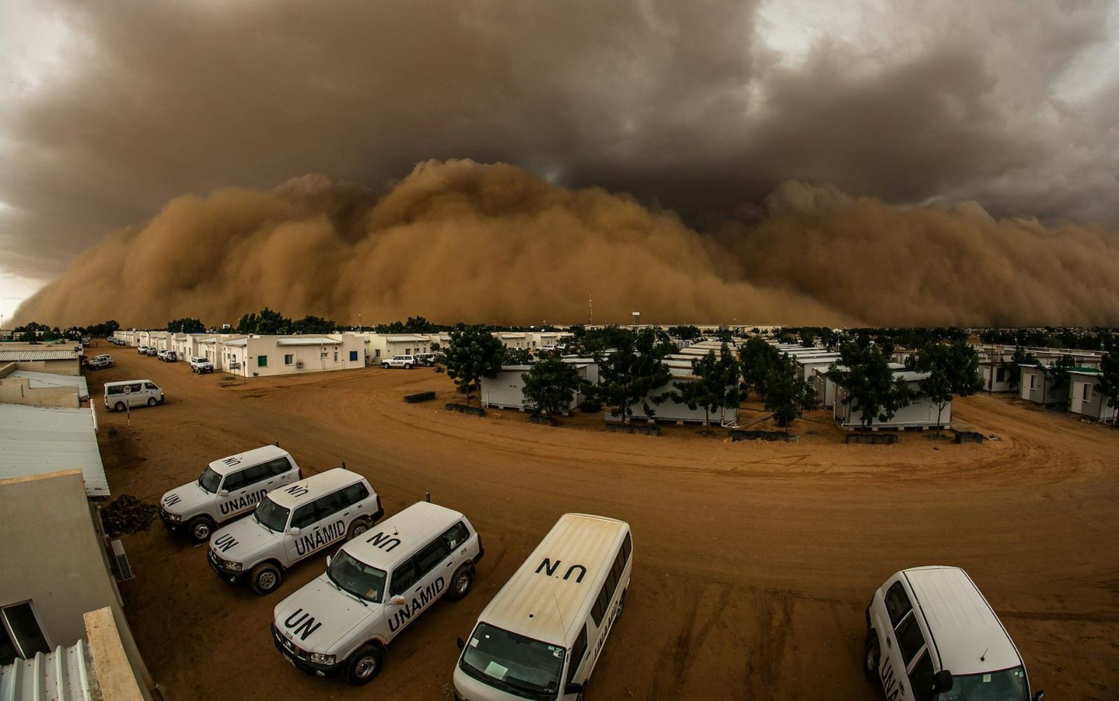
Sandstorm in El Fasher, North Darfur.
UNAMID / Foter, CC BY-NC-ND
Dust storms form when strong winds blow over soils composed of "erodible" and "mobilizable" materials—that is, soils sensitive to wind erosion. This is a very common phenomenon in vast desert areas, such as the Sahara, where storms extend for hundreds to thousands of kilometers.
In fact, in deserts, it is not the grains of sand that are carried by the wind over long distances, because the grains are relatively heavy and fall to the ground not very far from where they were lifted. Wind lifts the grains of sand a few inches to a few feet above the ground, and then they fall back. This generates an impact with the grains on the ground, breaking them into smaller particles. This process, known as saltation, produces much lighter desert dust grains, which descend very slowly due to gravity.
Once lifted, the dust can remain suspended in the air for several days, traveling with the wind across thousands of miles and even reaching the poles.
Dust storms have significant effects
The very large amounts of dust lifted from the Sahara play a major role in the Earth's climate and systems. They significantly alter Earth's energy balance by reflecting and absorbing sunlight and infrared radiation. Absorption of sunlight can substantially heat the air where the dust is located, thus altering wind circulation.
When deposited on the ground, dust also constitutes an essential supply of minerals for marine and terrestrial ecosystems. Moreover, desert dust storms greatly degrade air quality and visibility in North Africa, which may significantly affect the health of populations in these regions due to the exacerbation of respiratory diseases.
How storms are born and evolve
In the central Sahara, dust lifted into the atmosphere is most abundant in summer. Atmospheric conditions during this period are heavily influenced by humidity flowing in from the Gulf of Guinea via the winds associated with the African monsoon.
These moist air masses rise when they encounter obstacles, such as mountains, or when they pass over highly reflective soil that produces upward air currents. This triggers the formation of very large thunderstorms, whose precipitation cools the air abruptly as it evaporates upon contact with the extremely hot desert air. Pockets of cold air end up in a very hot environment—the sharp difference in air density between hot and cold areas causes extremely strong winds.
It is these winds that lift the mobilizable dust from the ground, creating gigantic walls of dust. Essentially, tropical storms in the desert are responsible for these dust storms, known as "haboobs," a term derived from Arabic meaning "strong wind."
Understanding these storms from space
We still know relatively little about the birth of these storms: on the one hand, they are sporadic in nature and triggered by complex dynamic mechanisms; on the other hand, atmospheric conditions make observations difficult, and the means of investigation are often very limited in desert regions.

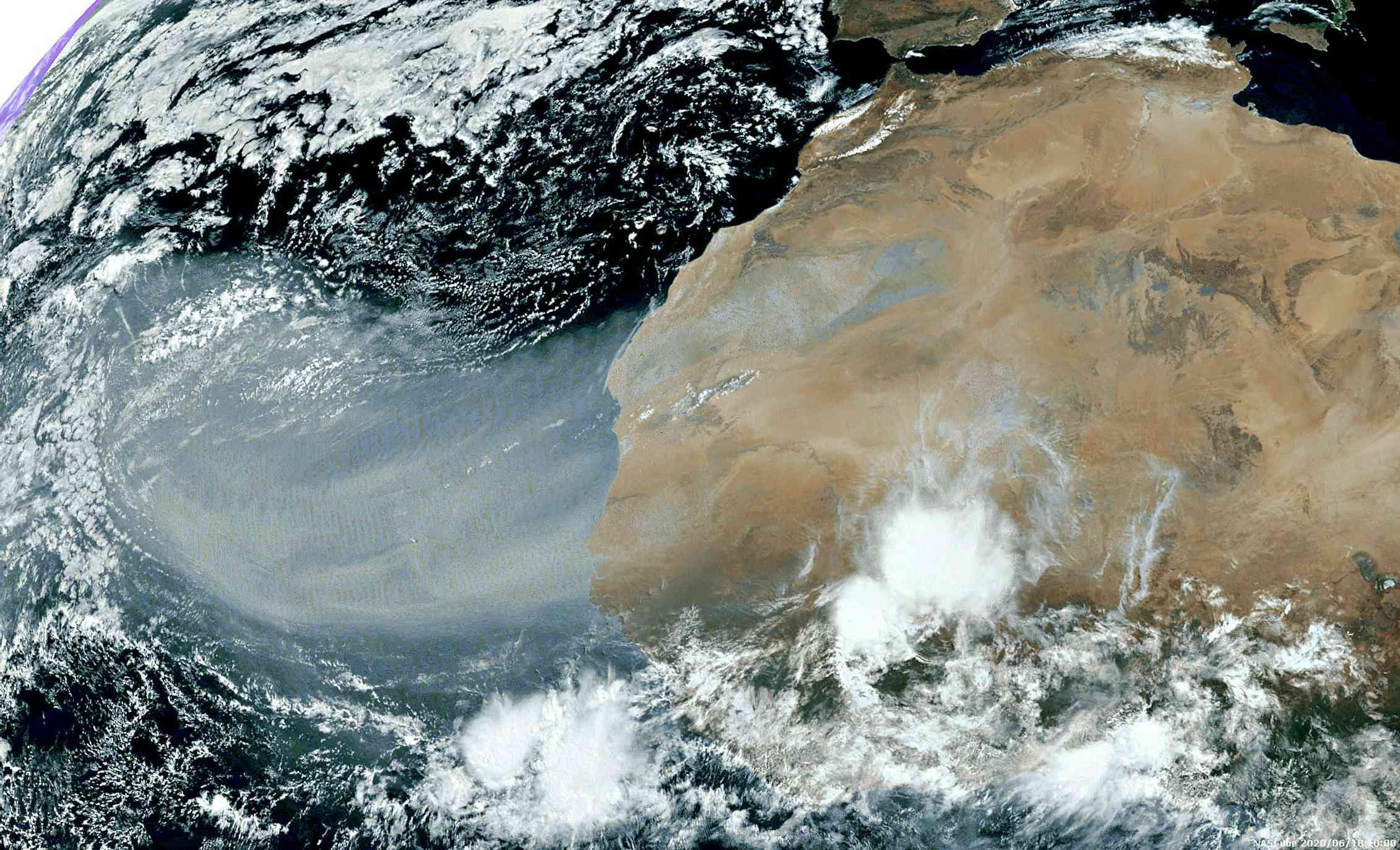
2D photograph of a vast Saharan dust storm in June 2020, taken by the SEVIRI sensor.
L. Gonzalez and C. Deroo, Atmospheric Optics Laboratory, Author provided
In these regions, satellite observations play a major role, allowing us to observe the quantities of dust lifted into the atmosphere and their journey to other regions. However, until now, traditional satellite observations only characterized the two-dimensional distribution of desert dust through horizontal mapping done by passive sensors, which operate similarly to high-performance cameras. Vertical information, showing the thickness of the storm, can be obtained by using a laser aboard the satellite, but this works only directly under the satellite's path—each acquisition is spaced about 1,200 miles (2000 km) apart in longitude.
The importance of 3D phenomena in storm evolution
Dust storms reach very different regions depending on their altitude, as wind speed and direction vary significantly with height. Likewise, the environmental impacts of dust also depend heavily on their vertical extent. Dust near the surface directly affects living conditions for populations by degrading air quality and visibility.
Dust can settle on the surface either due to gravity when in contact with the ground or due to washing out effects from rain droplets. The impacts on Earth's energy balance and atmospheric circulation predominantly occur at the altitudes where dust is present: the dust absorbs sunlight, thereby warming the air around it.
Additionally, our understanding of the vertical mixing mechanisms of desert dust in the Sahara is limited, given the lack of observations and the difficulties in modeling them using equations or numerical tools.
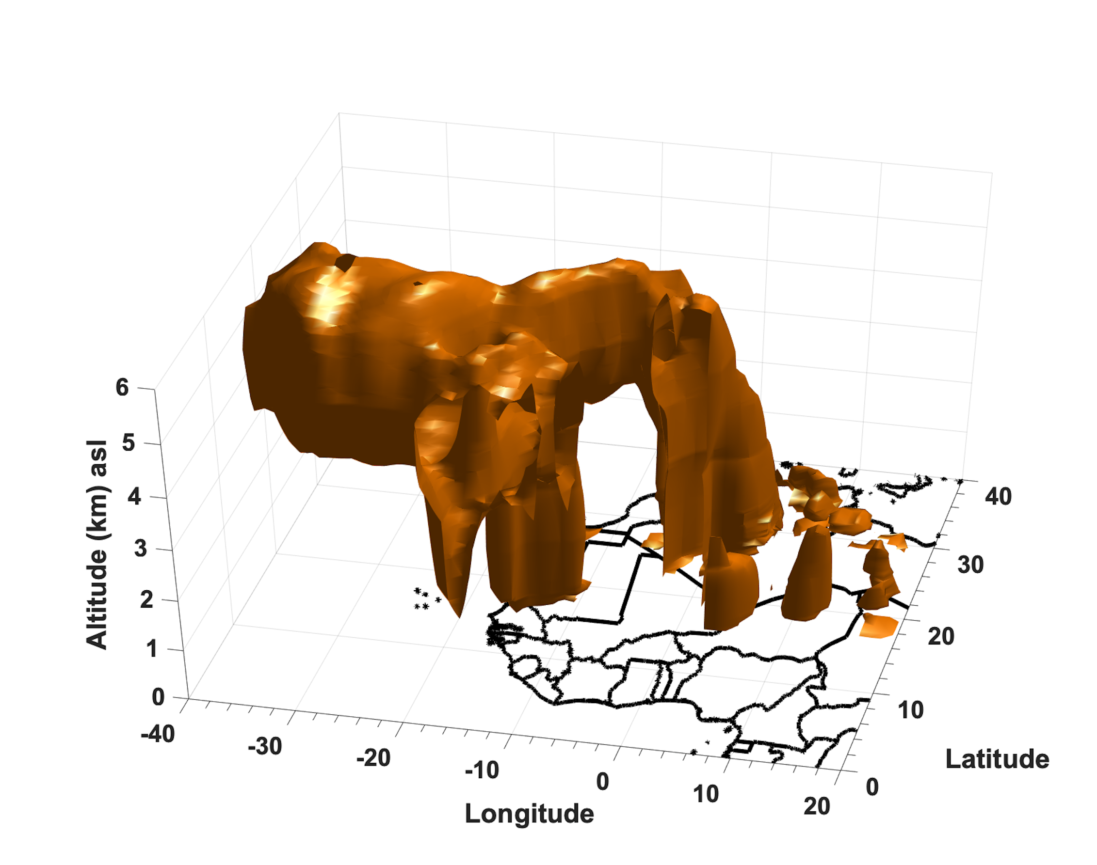
Recent scientific research has measured the three-dimensional distribution of dust during the birth of storms in the heart of the Sahara for the first time from space, specifically during the vast Saharan dust storm of June 2020, which reached the Caribbean and then the United States.

3D view of the vast Saharan dust storm of June 2020, obtained from thermal infrared measurements.
Juan Cuesta, Author provided
This work relies on an innovative method developed at the Interuniversity Laboratory of Atmospheric Systems, using satellite observations from the passive IASI sensor, which measures the intensity of light in the thermal infrared in a very precise and detailed way according to wavelength, that is, the color of the light. The great advantage of IASI is its spatial coverage: its measurements cover the entire surface of the Earth twice a day, whereas a laser sounded only directly beneath its path, spaced about 1,200 miles (2000 km) apart in longitude.
These measurements are sensitive to the vertical distribution of dust while being very detailed horizontally. This creates a 3D view of the extent of the dust, allowing for a better understanding of the dynamic mechanisms that give rise to dust storms in the Sahara during the summer. They offer great potential for studying the vertical mixing mechanisms of desert dust and an original way to enhance the accuracy of numerical models of the 3D distribution of dust.