Discovery of a second giant asteroid impact dating from the extinction of the dinosaurs
Published by Cédric,
Author of the article: Cédric DEPOND
Source: Nature Communications Earth & Environment
Other Languages: FR, DE, ES, PT
Author of the article: Cédric DEPOND
Source: Nature Communications Earth & Environment
Other Languages: FR, DE, ES, PT
Follow us on Google News (click on ☆)
This crater, named Nadir, is located beneath the sea near Guinea. It dates back to a pivotal period in Earth's history: 66 million years ago.

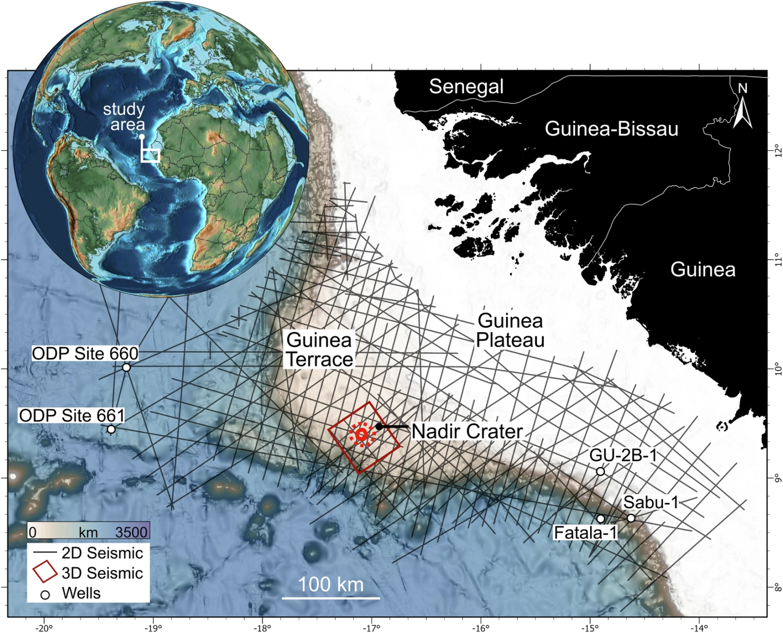
The MC3D seismic zone used for this study is indicated in red, with the outline of the crater shown after an estimated impact in the Late Cretaceous. The inset map shows the location of the crater on a paleogeographic reconstruction of the central Atlantic from 66 million years ago. This reconstruction was made using GPlates.
Buried under 300 meters (~984 feet) of sediment, this crater is nearly undetectable by traditional means. Seismic imaging allowed researchers to reveal its shape and to detail the events that followed the asteroid's impact.
Discovered in 2022, the crater measures around 8.5 kilometers (~5.3 miles) in diameter. The seismic detection technique, used to analyze the seafloor, provided a 2D and then a 3D image of this depression. This revealed a clear disturbance in the stratification of the sediments.
The impact responsible for the formation of Nadir would have triggered a huge tsunami. A wave of 800 meters (~2,600 feet) is thought to have crossed the Atlantic Ocean, drastically altering the surrounding landscape.
What intrigues scientists is the age of the crater: it coincides with that of Chicxulub, the asteroid linked to the extinction of the dinosaurs. Some estimate it could be a fragment of a larger asteroid. However, despite these hypotheses, uncertainty remains about the connection between the two events. Scientists are not yet able to precisely date the impact or determine if these collisions are related.

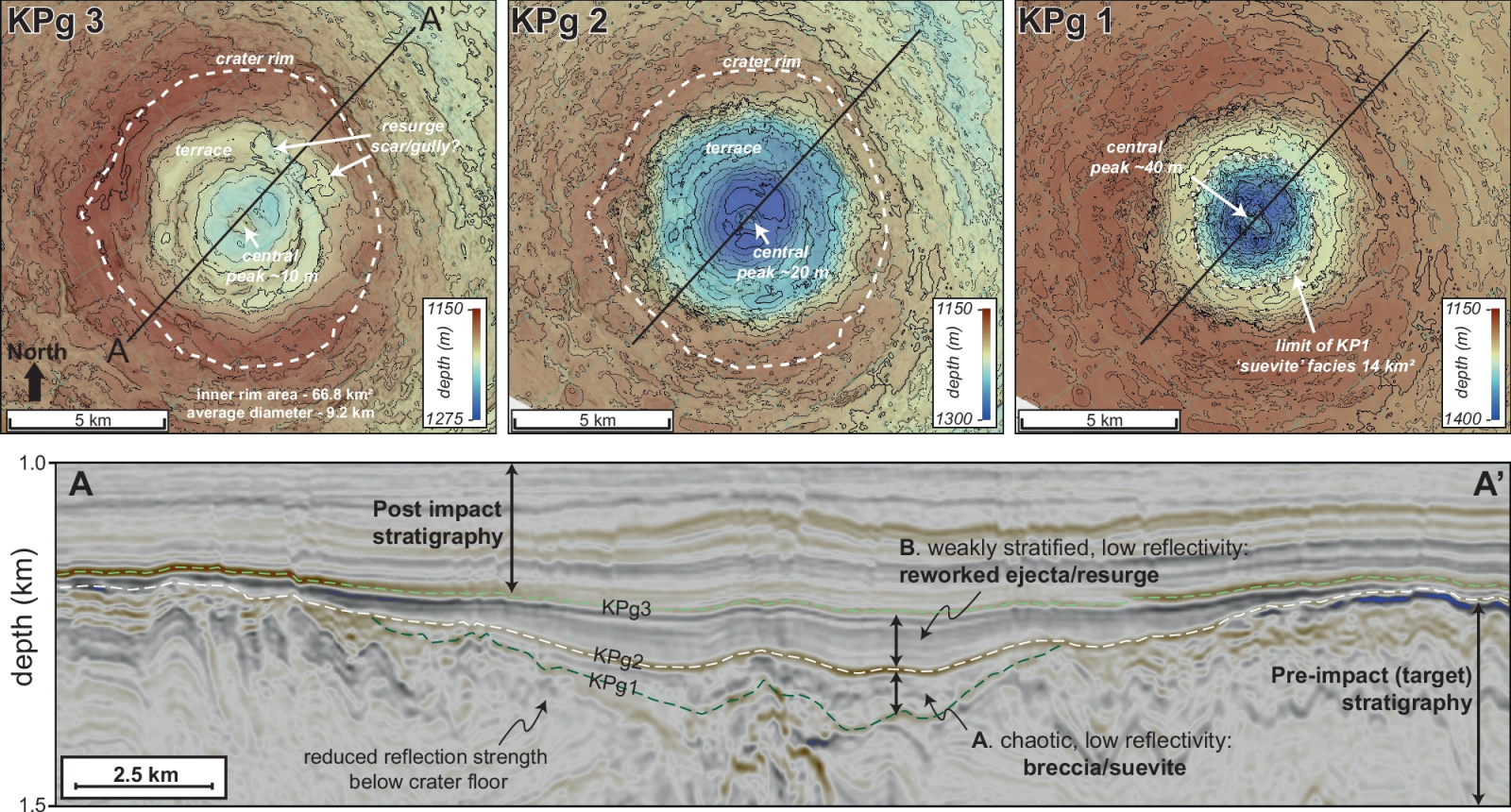
KPg1, KPg2, and KPg3 represent different stages in the evolution of a crater.
- KPg1 corresponds to the initial geometry beneath a unit of breccia/suevite,
- KPg2 to the crater floor after the modification phase,
- and KPg3 after the resurgence deposit.
All stages show a central uplift, terraces, and a well-formed rim. The depth of the crater decreases from KPg1 (~230 m) to KPg3 (~70 m), and its diameter averages 9.2 km. An uninterpreted seismic version is available as a supplement.
The 3D modeling of the Nadir crater represents a major breakthrough in understanding asteroid impacts on Earth. This first step could pave the way for new discoveries. Upcoming studies, such as planned drilling campaigns, will likely explore the crater's composition in more detail and provide new insights into this cataclysmic event.
Through these future analyses, researchers hope to better understand the global consequences of the impact on the marine and terrestrial environments of the time.
What is seismic imaging and how does it help discover underwater craters?
Seismic imaging is a geophysical technique used to explore the subsurface by sending acoustic waves. These waves, similar to those from earthquakes, pass through various geological layers before being reflected back to the surface. By analyzing the reflected waves, scientists can reconstruct an image of the subsurface, much like an ultrasound.
In the case of the Nadir crater, this method revealed a disruption in sediment layers, evidence of a massive impact. Instruments called geophones capture the waves after their journey, allowing the creation of highly detailed 2D and 3D images of the seafloor. This is how the structure of the crater, hidden beneath the sediment, was identified.
Seismic imaging is particularly useful in marine environments, where erosion is less significant than on land. This allows the discovery of well-preserved craters that have remained intact for millions of years, providing valuable information on asteroid impacts.
How is a tsunami generated by an asteroid impact?
A tsunami caused by an asteroid impact occurs when the object strikes a body of water, such as an ocean. The enormous energy released by the collision abruptly displaces a large volume of water, generating a series of massive waves.

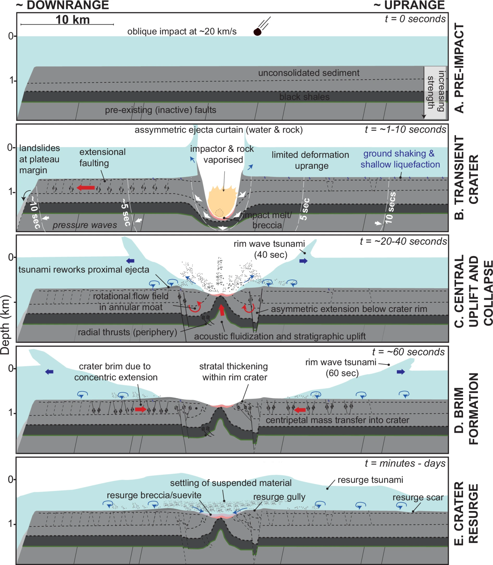
- A, B: Initial impact and formation of the transient crater.
- C: Initial stratigraphic uplift and collapse of the rim and annular trough.
- D: Concentric inward flow and formation of the crater's upper rim.
- E: Ongoing modifications from water resurgence and suspended sediment deposition.
Some stages may overlap or occur simultaneously.
These waves, initially formed near the impact site, then spread at high speeds over thousands of miles. The Nadir crater, for example, is thought to have generated a tsunami 800 meters (~2,600 feet) high after the asteroid struck the ocean floor. This shockwave would have traveled across the Atlantic, creating destructive waves along the coasts.